
The Yahara River Watershed (PDF) covers a quarter of Dane County and connects Lakes Mendota, Monona, Waubesa, and Kegonsa. Each lake has a minimum and maximum target lake level goal set by Wisconsin Department of Natural Resources (DNR) in 1979. In the summer of 2018, large amounts of rainfall and inefficient movement of water out of the system led to flooding in communities surrounding the Yahara chain of lakes.
In May 2018, the Dane County Regional Airport (located in the Yahara River Watershed) received the second highest amount of rainfall on record. Despite all four lakes being at summer minimum at the beginning of the ‘summer’ season, all four lakes rose above their summer maximum levels with Kegonsa reaching a historic high in July. The flow from Tenney Dam was decreased to minimize flooding in Lake Kegonsa. In August, the watershed received higher than average amounts of rain causing waterlogged soils. This culminated in an intense rain event on August 20-21 with parts of the watershed receiving over 10 inches of rainfall. This was followed by many more rain events in August, September, and October.
The following information describes many of the factors that contributed to the flooding and challenges moving water through the Yahara River and out of the system. This information was presented to the Dane County Board of Supervisors, Committee of the Whole on September 20, 2018. A recording of the presentation is available online.
The following factors reduce water flow, which contributed to the 2018 flooding:
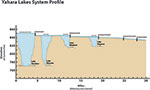
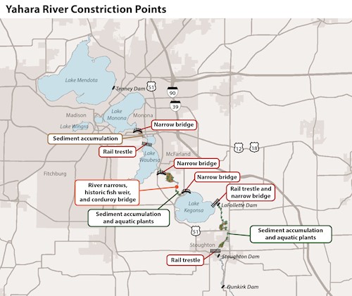
During normal conditions, the slope of the Yahara River is very flat with a drop of only 1.5 feet over 4 miles (0.007% slope) between Lakes Waubesa and Kegonsa. In comparison, the slope between Monona and Waubesa is 0.4 feet over 2 miles (0.004% slope). Because the landscape is so flat, water moves very slowly through the river and out of the system. Click to enlarge image.
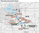
The Yahara River channel narrows or becomes shallower in several locations which slows down water flow. Examples of these constriction points include narrow bridges and shallow riverbeds due to layers of sediment accumulation from decades of erosion. Debris in the river, such as tree trunks and boulders, causes friction and slows water flow. In July 2018, 31 dump truck loads of debris (rock, pieces of metal, train parts, and trash) were removed from the river bed at the railroad trestle in Stoughton. The removal of debris increased water flow about 20%. Click to enlarge image.
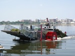
Aquatic plants cause friction and reduce water flow. The location and volume of aquatic plant growth is highly variable from year to year and must be continuously evaluated throughout the growing season. Every year aquatic plants are harvested in the Yahara River between Lake Waubesa and Lake Kegonsa. During the 2018 flooding, Dane County obtained special permission from DNR to harvest aquatic vegetation in the Yahara River south of Lake Kegonsa. This was the first year that there has been abundant plant growth in that section of the river. Between 5/21 to 9/14, 628 dump truck loads of aquatic plants were removed in the Yahara River. Over a 5 day period of 12-14 hour work days in mid August, 95 dump truck loads were removed which doubled the flow.
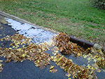
Debris, such as leaves and trash, can clog storm drains which reduces water drainage and can cause localized, urban flooding.
In addition to the factors listed above, other factors contributed to the 2018 flooding including:
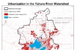
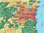
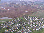
Currently, the Yahara River Watershed has approximately two times more urban area than it did in 1970. Urban areas have more roads, parking lots and other impervious surfaces which reduces the amount of water that soaks into the ground and increases surface water runoff. The amount of urbanization in the lake’s watershed impacts the amount of water the lake receives. The land around Lake Monona, for example, is highly urbanized so the lake receives increased amounts of surface water (stormwater) runoff while the land that drains to Lake Mendota has a higher percent of agricultural land. To learn more about stormwater runoff, watch this short video (YouTube). Click to enlarge image.
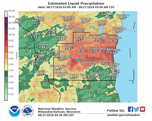
Heavy downpours are increasing nationally, especially over the last three to five decades. Since 1900, average annual precipitation in the Midwest has increased by roughly nine percent. Rainfall events have become heavier and more frequent per National Climate Assessment, 2017. In 2018, areas in Dane County experienced the second wettest May on record and an intense rain event on August 20-21. As of October 15, Madison has received 46.30 inches of precipitation which is 6.33 inches away from the record annual rainfall amount (52.93 inches in 1881). In 2018, heavy rainfall resulted in lake levels that were approximately 12-18 inches above summer maximum goals prior to additional rainfall in August 2018 which further raised lake levels to new historic highs. Click to enlarge image.
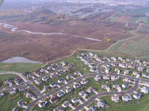
The watershed lost over 30% of its original wetlands in Dane County which reduces areas previously available for flood water storage. The photo shows wetlands in the Pheasant Branch Conservancy in Middleton which are surrounded by development.
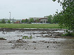
Soils that receive large amounts of rainfall can become waterlogged which reduces the amount of water that soaks into the ground and as a result more rainfall runs off the ground. In 2018, due to the rainfall received (see Rainfall Patterns above), many soils had waterlogged conditions.
