
As part of our goal to protect and improve surface water quality in Dane County, we are identifying, tracking, and reporting phosphorus abatement (reductions) from implemented conservation practices. These are structural or vegetative management activities used to reduce soil erosion and protect water quality.
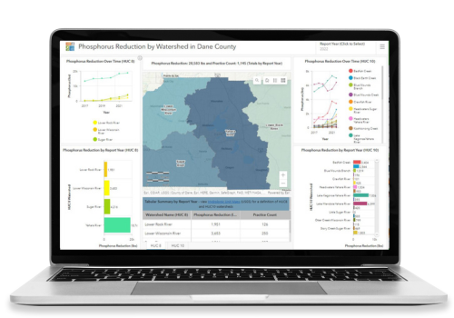
We designed a Phosphorus Reduction by Watershed Dashboard to summarize the phosphorus reduction data by two watershed sizes: HUC 8, medium-sized river basins, and HUC 10, smaller, more local sub-watershed basins. The dashboard displays data from 2017 to present with annual updates planned.
For additional information visit our Goals & Initiatives and Tracking Progress webpages.
The dashboard includes phosphorus reduction amounts from both management and structural conservation practices.
Management practices, or “soft” practices, require maintenance by the landowner and/or operator to keep the practice functioning. These practices often include plants that need to be maintained and/or reestablished annually. Examples of management practices include cover crops, harvestable buffers, critical area plantings, and prescribed grazing. Nutrient management and tillage techniques are not accounted for in this dashboard.
Structural practices, or “hard” practices, involve an engineering component to design and create a physical structure and do not need much maintenance to function. Examples of conservation practices include grassed waterways, roof runoff structures, grade stabilization structures, and waste storage facilities.
The phosphorus reduction calculations displayed in the dashboard are model-based and do not currently have field-recorded values. The specific model used is dependent on the type of conservation practice implemented and include, but are not limited to, the Barnyard Runoff Model (BARNY), the NRCS gully erosion calculator, and Wisconsin’s SnapPlus nutrient management software.
Note that not all agricultural conservation practices implemented in Dane County are included in phosphorus reduction calculations due to model and staff resource limitations. We have prioritized tracking data from conservation practices in the Yahara and Sugar River Watersheds. Our department has funding and contractual agreements to work in and report on practices implemented in these areas through Yahara Watershed Improvement Network (WINS) (Yahara WINS) and Regional Conservation Partnership Program (RCPP) (USDA NRCS).
